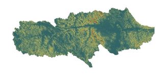
Upper Belle Fourche Watershed
|
The Belle Fourche River basin drains portions of Wyoming, Montana, and South Dakota. The headwaters begin in Northeastern Wyoming, flowing through Keyhole Reservoir, past Devil’s Tower National Monument, and towards the Northeastern corner of the state. Just South of the Wyoming-Montana state line, the Belle Fourche River turns Southeast and flows across the Wyoming-South Dakota state line into the City of Belle Fourche, South Dakota. In the Northern-most portion of the basin, tributaries of the Belle Fourche River drain a very small portion of the Southeastern corner of Montana. The Belle Fourche River eventually flows into the Cheyenne River after draining portions of Spearfish, Lead, Deadwood, Sturgis, and the Black Hills National Forest in South Dakota.
Citation: Wyoming Department of Environmental Quality, Belle Fourche River Watershed TMDLs for Pathogens, Ammonia, and Chloride. Cheyenne, WY: WDEQ, August 2013 The Belle Fourche River basin covers nearly 3,000 square miles within Campbell County. Sub-watersheds of the Upper Belle Fourche Watershed include; Donkey Creek, Caballo Creek, Buffalo Creek, Hay Creek, and Mud Spring Creek. |
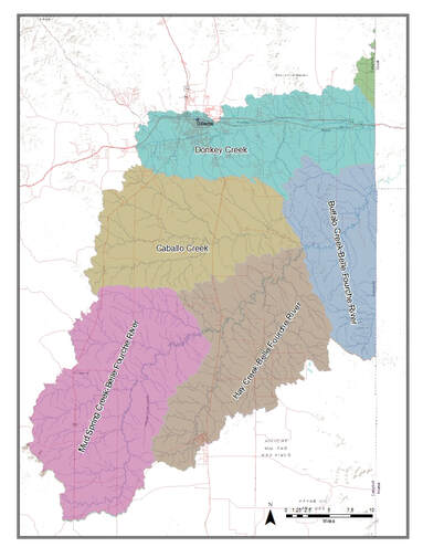
Sub-Watersheds of the Upper Belle Fourche Watershed
|
Donkey Creek Sub-Watershed
|
The Donkey Creek Sub-Watershed is located within the Upper Belle Fourche Watershed. Donkey Creek originates Southwest of Gillette, Wyoming and flows East through Gillette Fishing Lake. The creek follows Interstate 90 until it flows into the Belle Fourche River, near Moorcroft, Wyoming.
Stonepile Creek originates near Echeta Road West of Gillette. The creek is confined in an engineered concrete channel through the City of Gillette. South of Interstate 90, just East of Gillette, the creek returns to its natural channel and continues past the Gillette Waste Water Treatment Facility (GWWTF) prior to flowing into Donkey Creek. |
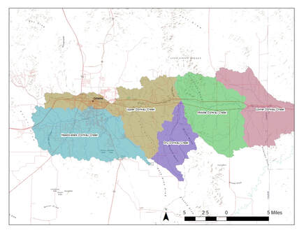
Donkey Creek Sub-Watershed
|
Donkey Creek Water Quality
|
E. coli continues to be a threat to the surface waters in Campbell County. There are several human health concerns related to the presence of E. coli, including stomach irritation, vomiting, and kidney failure. CCCD has monitored water quality at various sites on Donkey and Stonepile Creeks since 2002. Donkey and Stonepile Creeks are both designated as IR Category 4A, Impaired Waters with approved TMDLs. The Belle Fourche Watershed Total Maximum Daily Load (TMDL) document was completed in 2013 and contains recommendations for the Donkey Creek Sub-Watershed, which includes both Donkey and Stonepile Creeks.
E. coli limitations are monitored in all waters designated for primary contact recreation, during the primary recreation season (May 1 through September 30). Concentrations of E.coli bacteria shall not exceed a total of 410 Most Probable Number (MPN) per 100 milliliters. If a sample is taken which exceeds this number, CCCD staff notify the Campbell County Public Health (CCPH) office to recommend against contact with the waterways. Results from annual monitoring indicate that bacteria concentrations remain in excess of the WDEQ’s primary contact recreation standard. Currently, E. coli concentrations do not have a significant trend but instead continue to fluctuate, as in years past. There was a noticeable rise in bacterial counts within the 2016 sampling season, however, it is difficult to determine if these increases can be attributed to the recent climatic conditions or increased activity of significant sources. |
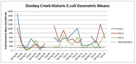
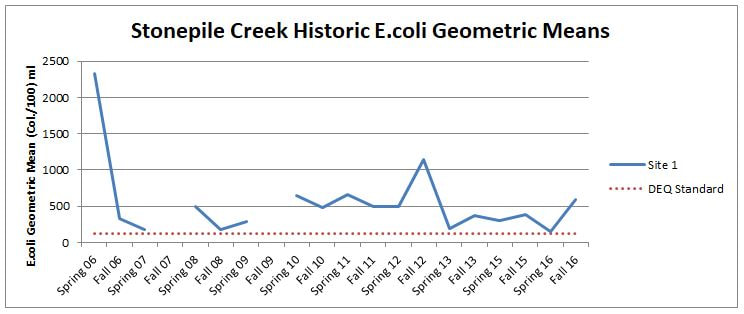
Graphs Showing E. coli Concentrations from 2006 - 2016
|
Projects and Reports
|
Donkey Creek Cost-Share ProgramDepending on availability of Federal and State grants, CCCD and the Donkey Creek Watershed Steering Committee may offer financial assistance for projects that will benefit water quality.
|

|
Donkey Creek Watershed Plan, 2016In 2016, members of the Donkey Creek Watershed Steering Committee met and agreed to initiate a revision to the watershed assessment and planning effort to address bacteria and other concerns within the Donkey Creek Sub-Watershed.
|

|
Donkey and Stonepile Creeks Non-Point Source Project, 2016Donkey and Stonepile Creeks are located within the Donkey Creek Sub-Watershed. These streams flow through the City of Gillette and are directly impacted by the City’s increasing population. E. coli continues to be a threat to surface waters within Campbell County. Due in part to the risks to the community, CCCD has actively monitored and implemented Best Management Practices (BMPs) to aid in improving the quality of water within the Donkey Creek Watershed.
|
|
Belle Fourche River Watershed TMDL, 2013The Belle Fourche Total Maximum Daily Load (TMDL) was completed in 2013 and contains recommendations for the Donkey Creek Sub-Watershed, which includes both Donkey and Stonepile Creeks. Donkey and Stonepile Creeks were removed from the 303(d) list following the completion of the Belle Fourche TMDL, and re-designated as IR Category 4A Impaired Waters with an approved TMDL.
|